The story of the post-medieval Sveti Pavao shipwreck takes us to the southern Adriatic, to the southern side of the Croatian island of Mljet and the Sveti Pavao shallows located approximately five kilometres west of Saplunara Bay. Sometime in the second half of the sixteenth century, a Venetian merchantman hit the shallows and, over five hundred years later, in 2006, the wreck of the ship was discovered by chance and immediately placed on the list of the most important archaeological sites in the Republic of Croatia. It is not the only shipwreck dating from the post-medieval period – a merchantman from the same period was found near the island of Gnalić – but its route and cargo differed significantly from the Sveti Pavao wreck.
Discovery
In 2006, divers from the diving club Sava-Medveščak acquired a permit to dive in the waters around Mljet. It was a stroke of good fortune that Jurica Bezak, an underwater archaeologist employed by the Croatian Conservation Institute, was a member of the dive team. During one of the dives, Bezak spotted the shipwreck and reported his discovery to the authorities. The first official survey of the site took place the following year and was led by Igor Miholjek, head of the Department for Underwater Archaeology of the Croatian Conservation Institute. The team of underwater archaeologists was amazed by the untouched shipwreck and the many clearly discernible parts of the ship's structure, cargo, and equipment: seven bronze artillery pieces, numerous ceramic vessels (plates, jugs, and bowls), glassware items, and a number of small metal objects. The divers immediately recognized the immense archaeological potential of the site and named it after the dangerous underwater shallows where the merchantman had sunk: Sveti Pavao.
Maritime Routes and Navigation
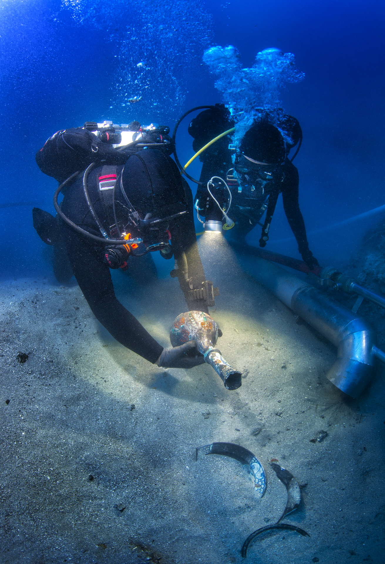
Navigation across the Eastern Adriatic has been a perilous endeavour since ancient times as is evident from the number of shipwrecks that took place over the course of the centuries: from antiquity, the Middle ages, and all the way to the modern period. The currents favour navigation from the south to the north, but vary somewhat during summer and winter. Although post-medieval ships had numerous advantages over those from antiquity, which required a tail wind to navigate, the post-medieval vessels also foundered when confronted with the pure force of strong winds and storms, not to mention perilous reefs and shallows. The two prevalent winds in the region (the bura and jugo) permit normal navigation until they became too strong and stormy. Because of these winds, ships rarely navigated the passage during late autumn and winter, and well into the middle of the spring. The shallows near Mljet can hardly be seen even during calm weather and become extremely dangerous when the strong southern wind blows, and the seething sea and high waves hide the dangerous summit of the shallows. A tempest probably threw the ship off course, and the captain, unfamiliar with local waters, steered the ship towards the shallows where it directly hit the summit, took on water, capsized, and sank to the seabed, coming to rest at a depth somewhere between 36 and 47 meters. The depth of the wreck presented a challenge to researchers as the remains of the ship are scattered over an area of almost 12 by 10 meters, and the divers had relatively little time at the bottom. For this reason, the archaeologists had to carefully plan the research, drawing both on archaeological methodology and the technical diving skills necessary when working at such depths. Divers conducted one dive per day, taking breaks every couple of days, depending on the tasks of individual divers. In order for them to be able to stay at the bottom for a longer period of time and also to increase their safety, divers used an enriched air nitrox gas mixture. Decompression was handled by using 100% oxygen (starting at a depth of six meters). Extra diving tanks were placed at the bottom as an additional safety measure. A shot-line connected the diving platform (usually a large boat) to the site. The dives were conducted in pairs and each diver had a specific task – excavating, documenting, and retrieving finds, or taking photographs.
A Pristine Site and its Finds
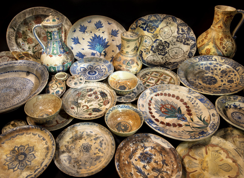
Although the Croatian waters hold numerous shipwrecks, it was immediately apparent that the Sveti Pavao wreck was unique because of its state of preservation. The Sveti Pavao was a rare example of an intact shipwreck, untouched by looters who have pillaged and destroyed many underwater cultural heritage sites. After the first dive and the retrieval of several ceramic vessels, Ljiljana Kovačić of the Dubrovnik Archaeological Museum confirmed that the finds were Ottoman pottery manufactured in the town of Iznik in the second half of the sixteenth century. Due to the significance of these initial discoveries, Igor Miholjek gathered an experienced group of archaeologists, divers, and photographers for an extended period of excavation and research which took place from 2008 to 2020. A special collaboration was established between the Croatian underwater archaeologists and an Italian team from Ca'Foscari University in Venice from 2010 to 2012. Among other things, the collaboration produced the 2014 publication entitled Sveti Pavao Shipwreck covering the current state of the research project and providing a complete overview of the site. Igor Mihajlović, an underwater archaeologist from the Croatian Conservation Institute with an expertise in artillery pieces excavated from Croatian underwater sites, analysed the ship's ordnance. Merchantmen usually carried artillery for defence against pirates who preyed on their valuable cargo. Mihajlović identified the Venetian origin of the ordnance and provided a detailed report on its primary features (weight, decorations, founder's initials, morphological characteristics, etc.), and on other projectiles also discovered at the site. His findings substantiated the theory that Venetian merchantman transported valuable goods from Iznik towards commercial centres across Europe. Vesna Zmaić Kralj examined the Iznik pottery, the ship's cargo, and the most important part of the wreck. She made a distinction between the luxurious ceramic vessels from Iznik and the rest of the pottery, generally Italian glazed pottery used in the ship's galley, and other examples of Ottoman pottery (ibrik jugs and smaller amphora).
Iznik Pottery – A Rare Underwater Find
Iznik pottery is literally the star of the show. In the fifteenth and sixteenth century, the name of Iznik became famous throughout the world thanks to the city's developments in manufacturing ceramics. Turkish ceramic art combined Chinese and Asian influences, and with the patronage of the imperial court, blossomed into an artistic and technically advanced industry. Iznik, a walled town lying on the eastern shore of Lake Iznik in Turkey's Marmara region, was the main Ottoman centre for manufacturing the painted ceramic tiles and pottery that came to adorn many famous locations including the Süleymaniye Imperial Mosque and the Blue Mosque in Istanbul. The production of ceramic tiles is fundamental for the production of ceramic vessels, but because of our topic, we will focus on ceramic pottery rather than on tiles. The production of Iznik pottery is closely connected to Chinese porcelain, or more accurately, Iznik ceramics emerged because of the lack of Chinese porcelain. It is thought that the first samples of Chinese porcelain were used during the reign of Sultan Mehmed II but became scarce and difficult to acquire during the reign of Sultan Bayezid. The scarcity promoted local potters to find a way to produce ceramics comparable to Chinese porcelain. At the end of the fifteenth and beginning of the sixteenth century, these efforts resulted in the production of a white paste ware with a fine and regular transparent glaze. Although Iznik pottery was highly praised and shipped to major commercial centres of the day such as Dubrovnik, Venice, and Genoa, the overall number of preserved examples of Iznik pottery is extremely small and mostly owned by private collectors and/or museums. Zmaić Kralj identified four manufacturing phases within the cargo, and provided information on each phase, with detailed descriptions of the discovered finds and their decorative features. It is very rare to find so many phases of Iznik pottery in one place, let alone on an underwater site, and this was a great surprise for the archaeological team.
Metal Finds – Dating the Wreck
The discovery of the ship's bell represented a significant step forward in dating the shipwreck. Bells were used on merchant ships for signalling, keeping time, sounding alarms, marking the passing of time during the day, a safety alert in foggy conditions, a warning sign in case of danger, and to announce the presence of important persons. The ship's bell was found during the third year of the Sveti Pavao research project. It was analysed by Bezak who noted the sequence of Latin letters MDLXVII, signifying 1567, the year when the ship was probably first sent to sea. Prior to the discovery of the bell, the ship had been roughly dated by the Iznik pottery and artillery pieces to a broad period covering the sixteenth century. The newly acquired information from the bell served as a terminus ante quem: namely, the year before which the ship could not have been lost in the accident. Various coins, some of which were of Ottoman provenance (analysed by Garo Kürkman) and some of European provenance (analysed by Zmaić Kralj) provided other important pieces of information. Fifty pieces of Ottoman coins (akches) recovered from the wreck in 2009 and 2010 were found melded together with two silver thalers. They were probably originally kept in a leather sack that had disintegrated in the salty environment. The akches made it possible to more precisely date the wreck because each new Turkish sultan, when he came to power, reminted the coins of his predecessor in his own name. The Ottoman culture prohibited the use of outdated currency and therefore the coins discovered at Sveti Pavao probably belonged to the captain who collected them in various ports. The akches bore the names of four different sultans who reigned between 1512 and 1595, the fourth of which was the twelfth sultan, Sultan Murad III (Sultan Murad III bin Selim II) who reigned between 1574 and 1595. This provided yet another piece of the puzzle to help pinpoint the date of the ship's demise. The two Saxony thalers found melded together with the Ottoman akches were dated to the period between 1544 and 1559 suggesting that they were the actual trading currency on the ship (and that the owner of the coins was also probably the captain). All things considered, we conclude, given the life span of merchantmen of that era, that the ship probably sank between 1574 (date of the first minting of the most recent coins of Sultan Murad III) and 1585.
The Ship's Frame
An important part of the shipwreck is the ship itself, or rather its wooden remains, the ship's frame. The remains were discovered a few meters to the east of the large concentration of finds, partially preserved under a layer of sand on a sloping seabed at a depth between 38 and 41 meters. The wooden construction was covered with ballast stones that had been used to provide stability to the ship by lowering its centre of gravity. The underwater excavation uncovered approximately eight meters of the ship's construction, and another excavation conducted in 2020 uncovered another large section of the ship, the remains of which, combined with the previous section, spread over a length of more than twenty meters. The two anchors situated at a depth of 46 meters are presumed to be in their original position. Therefore, the overall length of the ship's frame may well extend over twenty-five meters when completely uncovered.
Research Methods and New Techniques
Underwater excavation methods do not differ significantly from conventional archaeological methods and practices except that the research is conducted in an aqueous medium. The excavation of the wreck is accomplished, as has been the standard for a long time, with water dredges that displace the sediment from the bottom, uncovering the deeper layers where archaeological finds tend to be located. In contrast, documentation methods have changed a great deal over the years: from the use of fixed quadrants (aluminium rods and measuring tape dividing the site into squares that facilitate the recording of movable finds) to photogrammetry, a necessary tool in contemporary underwater archaeology. Photogrammetry is a technology that generates reliable quantitative information about physical objects and the environment by recording, measuring, and interpreting photographic data obtained through image sensors, most often DSLR cameras. Simply put, it is a computational process that composes a 3D model of an object using photographs of the same object. The technology is based on the fact that an image is created according to certain geometric and optical laws, and these laws can be used to reconstruct the recorded object. In order to arrive at the object's three-dimensional characteristics, a large number of overlapping images of the object are processed. The software calculates and triangulates the photographed points, arranging them into a 3D model of the object. Photogrammetry applications have become a "must-have" in underwater archaeology because they greatly facilitate the underwater documentation process and increase the safety of divers, replacing the arduous process of measuring with tape, increasing the accuracy of the measured objects, and shortening the dive time necessary for completing the task, and in some cases time spent by divers in a decompression regime. Moreover, in cases where researchers need to cover a larger area, they can resurface and continue the work in subsequent dives. The final result is a highly accurate blueprint of the site in a local coordinate system in which each visible element (e.g. each find) is given a numerical value (x,y,z). The 3D model can also be presented to the general public. In the case of Sveti Pavao, the 2010/2012 photogrammetry was produced by an archaeologist from the Ca'Foscari University, and the subsequent photogrammetry by the author of this article, assisted by the underwater photographer Jerko Macura.
Why We Do What We Do
The material retrieved from the site could not have been displayed without the hard work of conservators from the Croatian Conservation Institute (Maša Vuković Biruš, Mihael Golubić, Mladen Mustaček) and the employees of the former CCI workshop in Zadar who were responsible for restoring and consolidating retrieved material. The artillery pieces were desalinated, sediment and corrosion deposits were removed, and surfaces protected and stabilised. At the time of retrieval, the precious Iznik pottery had been damaged and degraded by the presence in the environment of items made from iron, which infiltrated the structure of the ceramic turning it black or brown. After a long process of cleaning, mending, and colouring replacement parts, the pieces shone as if they had just emerged from the medieval workshops of Iznik. The results of all these years of hard work were displayed to the public both in the previously mentioned publication and in two important exhibitions: at the Mimara Museum in Zagreb in 2015 and at the Dubrovnik Museums in 2016. The exhibitions displayed all the finds recovered from the Sveti Pavao wreck thus far, giving visitors the opportunity to be in direct contact with the story. These exhibitions are important because they bring our work closer to the general public. People do need to be connoisseurs of Iznik pottery to realise its great importance and to experience the beauty of the items recovered from the wreck. This was made clear by the large number of enthusiastic visitors to the exhibitions.
What the Future Holds
The Sveti Pavao site is unique because it represents a time capsule, an untouched site. Since its discovery, we have thoroughly researched the site and we hope that this research will continue for years to come. Since the beginning of the project, each year has brought something new to the surface, whether it was a large quantity of Iznik pottery, the ship's bell, coins, other types of pottery, or artillery pieces. Put together, these finds tell us an interesting story about the way of life on a merchantman from that period, about the commercial connections between two great adversaries who waged war, but still engaged in the trade of valuable commodities. The wreck gave us an opportunity to research relations between the Eastern and Western Mediterranean, and confirmed yet again that important navigational routes passed alongside the Eastern Adriatic coast. The large number of exquisite finds of Venetian and Ottoman provenance helped to determine the origin of the ship as well as its destination, and confirmed that trade between the east and the west remained robust during the fifteenth and sixteenth century. Although a large part of the site has been researched, the work is not yet finished. The wooden frame of the ship still remains buried beneath deep layers of sand at a greater depth, and, once uncovered, may give us insight into construction techniques of the period about which we have little written information. The same is true for movable finds many of which no doubt also remain hidden under deep layers of sand. We hope to develop better methods and practices that will help us to continue presenting the Sveti Pavao wreck to the general public. The two previous exhibitions, their catalogues, and the book on the subject of the wreck were received with great interest. As archaeologists, we must strive toward protecting and presenting the valuable cultural heritage we have inherited.